Juneau Alaska Trails: Walking, Biking and Hiking
Juneau Alaska trails offer superb opportunities for hiking, biking and walking. The scenery and opportunity to observe wildlife are unparalleled. Great mountains for steep hikes and alpine views; hidden coves and lakes for leisurely strolls; surreal contemplative corners to watch wildlife and spectacular scenery.
Exploring the great outdoors and adventure travel activities continue daily despite an occasional showers. Mountains with misty clouds draped about their shoulders are softened and magically beautiful. Over a hundred trails exist nearby. Some of our favorites are outlined here.
The City hosts guided hikes and walks every Saturday and Wednesday - call (888) 868-6328 for this weeks location. The USFS hosts interpretive walks departing from the Mendenhall Glacier Visitors Center twice daily in summer. Audubon Society hosts regular bird watching walks 1-2x week. Gastineau Guiding provides guided hiking tours from easy to challenging. Review and order guided tours and other excursions, if desired, at our main order form.
TRAILS
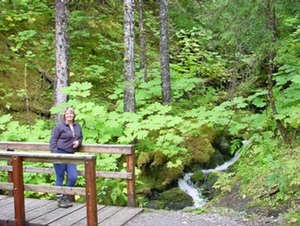
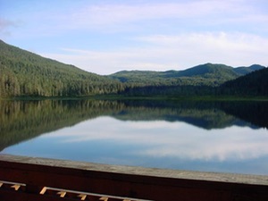
Mendenhall River/Montana Creek Trail (2-3 hours: Easy)
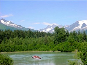
One of our favorite hikes! Begins practically out our back door! Or, if you’re on the road park at Brotherhood Bridge (10 mile Glacier Highway; perfect site for photos of the glacier) and hike, bike, walk, or jog this easy trail through the forest and meadows. Excellent cross country ski trail in winter. (Click on pictures for larger view.)
Perseverance/Granite Creek Trail 2-3 Hours; Difficulty Level: Easy to Moderate
The Perseverance Trail is the former road/trail taken by miners working the Silverbow Basin Gold mine. It is easy, picturesque, with many an interesting site and history. Read on: Juneau was first founded by Joe Juneau and Mr. Harris. They were looking for gold and were taken to Gold Creek (appropriately named) by a local Native leader (who could care less about the stuff). In any event, Juneau (originally known as Harrisburg) was founded in or about 1880.
To get to Perseverance trail, take Main Street to Sixth. Turn right on Sixth and follow to East Avenue. Turn left. East turns into Basin Road. Take Basin Road to the end (trailhead is marked). Various scenic viewpoints begin within blocks as you overlook the river valley. A little further, you will have an opportunity to picnic or relax above Ebner Falls.
Opposite the Ebner Falls cutoff is the cut off for the Mt. Juneau/Juneau Ridge Trail (very difficult, but great!). Approximately one mile beyond Ebner falls to the left is the Granite Creek Trail: good salmon berries on the hill, and a back of accessing Mt. Juneau (as well as Mt. Olds, Clark's Peak and a series of other mountains and ridges. Bears are frequently seen on the moraine flats at the end of the Granite Creek Trail.
More recently, Juneau Trail Mix (a local group of volunteers) has established a new trail leading from Perseverence to the Glory Hole. The Glory hole was created as miners would blast under a dome of earth and have it collapse, mine the ore, and then blast yet deeper. The excavation is approximately 1/2 mile long and 1/3 mile wide and drops straight down for perhaps 700-1000 feet. Those who get dizzy at heights, beware!
Mendenhall Wetlands (Approx. 45 min. Difficulty Level: Easy)
The Mendenhall Wetlands is immediately adjacent to the Airport, accessible off Ratcliffe Road. The area overlooks the wetlands between the mainland and Douglas Island and is a bird watcher's paradise. Canadian Geese, ducks, song birds and sea birds abound. Some educational signs have been placed on the trail relating to the birds, wildlife and ecology of the area.
The trail, incidentally, is one of the old roadbeds servicing the old dairy farm that used to exist on the grounds of the airport. That is also one of the reasons the frontage road running alongside Egan Drive is called Old Dairy Road.
East Glacier Trail Loop (Approx. 2-3 hours Difficulty: Moderate to Intermediate)
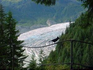
This is one of the all time favorites. The trail starts in back of the Visitor's Center at the Mendenhall Glacier. Climb the stairs leading above the Center, walk a few blocks and turn left. Most of the trail is a gently rising path along the bordering hill of the Glacier Valley. Towards the end there are a few switchbacks. It is well maintained. Great views along the way of the valley and Glacier.
Approximately 2/3 of the way up is AJ Falls, a nice picnic area. We have never had trouble drinking the water at the falls. However, be aware that Giardia is always a danger in Juneau streams. The top of the trail overlooks the Glacier and Nugget Falls. (By the way: One can also readily hike to the base of Nugget Falls (15 minutes) from the Visitor's Center. Great Photo ops!) This trail is one of the few which loops back through different scenery. Keep following the trail after you reach the overlook over Nugget Falls. To your left, you may be able to catch glimpses of the reservoir and old coffer dam built in the mining days. If you want to scramble down the hill, you will note a cable over the dam and reservoir. This was used to transport people and supplies over to housing.Or, follow the well defined trail as it veers off to the right and hike down the hill in the quiet canopy of the rainforest. Mosses, lichen, skunk cabbage, and mushrooms abound. The trail ultimately exits with the Nature Trail walk near the Visitor's center.
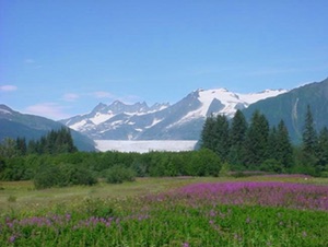
West Glacier Trail/Ice Caves (Approx. 3-5 hours Difficulty: Moderate to Intermediate)
Pick up the West Glacier Trail at the end of Skater's Cabin Road off Montana Creek Road. The first part of the trail is a gentle walk in the forest bordering Mendenhall lake. Approximately a mile in, the trail begins to climb. Several great lookout points provide panoramic views of the glacial carved valley, lake and glacier itself.
Approximately 2 miles in, the trail will cross a rocky area and stream. A bit further and the adventurous may climb up a knoll and follow survey tapes and cairn markers up Mt. McGinnis (later under Mountains).
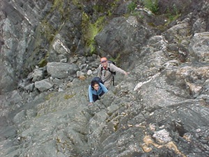
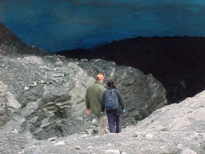
To access the ice caves. At the first viewpoint (that with the covered bench), head down the small auxiliary trail closest to the main trail. At points, the trail may get a bit wet. There are some fairly sheer areas to climb as well. However, the ice caves and close up of the glacier can make up for the difficulty.
The caves change monthly. It is possible to climb aboard the Glacier (crampons, ice ax and gloves a must!) and walk on top of the glacier. However, understand that any activities around the glacier itself are extremely hazardous and must be taken at your own risk. Do not go into or too close to the ice caves, since they are very slippery, lead to no-one-knows-where, and can collapse without warning. Do not walk on the glacier unless you are aware of things to watch and/or are with someone familiar with glacier trekking.
In the past, the Mendenhall Glacier normally receded approximately 70 feet per year. Lately, it has been receding at up to 600 feet per year. Good pictures and descriptions of its movement are available at the Forest Service Visitor's cabin. Most of the bedrock leading to the ice caves were covered at the time we first moved to Juneau in 1974. The pond at Pearson's Pond was created by the Glacier in the mid-1700's, as far as we can determine. Our property backs on the terminal moraine.
Windfall Lake Trail (4-5 hours round trip. Difficulty Level: Easy to Moderate)
At approximately 25 mile Glacier Highway just before the Herbert River, park immediately next to the gravel road on the right leading to trailhead. Trail meanders by Herbert River and through the forest. Lake has a cabin (reservations available through the State DNR) and good cut throat fishing.
Herbert Glacier Trail: (Goat Mountain Trail) (Moderate difficulty, 5 hours round trip by foot; 2.5 hours by bike)
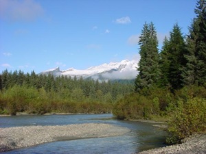
Trail head is one of three at approximately 25 mile Glacier Highway just beyond the Herbert River. The entire trail is relatively flat with scenic views along Herbert River. The terrain and grounds gradually change as you get closer to the glacier. Tall forests become alder and smaller vegetation. Eventually you break into the vast moraine left behind by the rapidly receding glacier. Bears or other wildlife are sometimes seen on the moraine. Note: the trail was recently upgrade and is now passable on bicycles!
Eagle Glacier Trail: (7 hours round trip. Difficulty Level: Easy to Moderate)
Just a bit beyond the 25 mile marker, on the other side of the Eagle River. The trail itself is a pain (lots of roots; some boggy areas). At the end, however, is a beautiful lake, glacier and cabin (reservations available through the State DNR).
Spaulding Meadows Trail
The trail begins at Glacier Highway mile 12.3. Sometimes muddy in the warm season, it leads to the John Muir cabin (reservations requird) and great Nordic skiing in winter. Trail starts on old corduroy road that leads to first of three muskeg meadows. Terrific views of Chilkat Mountains, upper Mendenhall Glacier, Lynn Canal
Auke Lake Trail
11.3 mile Glacier Highway. One mile or three if you circumnavigate the lake, this lovely and fairly easy woods walk along the lake shore is home to tall trees, beaver, otter, squirrels, fish, waterfowl, and bird life.
Bridget State Park Trail
Just before Echo Cove (near the northerly end of Juneau's 50 miles of highway) is the State's Bridget Point State Park. A nicely maintained trail leads through a variety of ecologies (muskeg, forest, grassland) to three of the State's cabins, and a very nice overlook of Lynn Canal.
MOUNTAINS
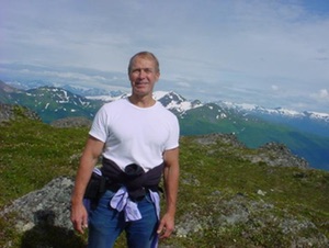
Juneau has an amazing number of fully accessible mountains and ridges. This site will concentrate on four or five of the most popular. All take about 7-8 hours to climb and return at a moderate pace. Those interested in further climbs may want to contact the Juneau Alpine Club. A variety of pictures of their various hikes are posted at the club's site.
These trails should not be tried by the timid. Mt. Juneau, Jumbo and McGinnis have various steep areas. All require stamina and care. Take lots of water, energy foods, and layered clothing (since the top can be windy and cold). Check the weather and bring rain gear if there is any chance of rain. Let someone know where you are going and when to expect you to return. A guide (or at least someone familiar with the trails) is strongly recommended. Views are spectacular and worth the effort.
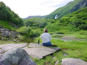
Mt. Juneau: (Approx: 7-8 hours round trip; Difficulty: Advanced and strenuous)
Access via Perseverance Trail (downtown off Basin Road). Approximate elevation gain is 3500 feet via switchback trails with the final steep area near the the top. Enjoy panoramic views of Juneau and Gastineau Channel along the way with a sweeping vista of the entire channel from the Taku Inlet to Lynn Canal at the summit.
You will typically find snow patches at the top (great for snow cones and replenishing water after a hot climb!) and gently rolling hills along the ridge. To return via a different route, one can follow the ridge to Granite Creek Basin (be sure to bear to the left and go up the final ridge!) which, in turn, connects to Perseverance Trail. One can access Mt. Olds from the Juneau Ridge. The truly brave can cross over the Salmon Dam ridge to Observation Peak and return via Cairn Peak and Blackerby ridge, but a guide is strongly recommended for that. Lots of steep areas with loose material.
The mountain doesn’t involve any technical climbing, just stamina and perseverance. There are some tricky parts in accessing Granite Creek from the ridge if that is desired. Be sure to talk to someone first in regard to the route! Basic concept: just keep following the ridge up, up, up and to the left (even though the right may look inviting).
Mt. Jumbo (aka Mt. Bradley): (Approx. 7-8 hours round trip; Difficulty: Advanced and strenuous)
The trail head is located off 5th Street in Douglas. It is the highest mountain on the island at 3500 ft. The trail is well defined and in good shape. It begins gradually then steepens sharply. After climbing, the forest breaks and then you are in tundra rocks and in need of perseverance to continue on to the crowning views of Gastineau Channel, Stephens Passage and Icy Straits. Snow at the top for refreshment. Sights from the top well worth the burning legs!
Mt. McGinnis: (Approx. 8-9 hours round trip; Difficulty: Advanced and strenuous)
Access at end of West Glacier Trail to the left. Scramble up the exposed granite areas to the top of the knoll. Cut along the knoll toward the mountain and locate the path leading into the woods. From here the trail is well defined. Be sure to note where and how to catch the beginning of the path on the way back down, since you may otherwise miss it.
The path goes up, across meadows and up again. There are a few false summits, keep going, but stop and enjoy the spectacular views at every break. Above tree line, look for rock cairns thoughtfully left as markers. Unlike many of the accessible mountains in the Juneau area, the top of McGinnis is fairly small. One gets a sense of real elevation and outstanding panoramic views of the Mendenhall Valley.
Thunder Mountain (Heintzleman Ridge): (Approx. 8-9 hours round trip; Difficulty: Advanced and strenuous)
Popular access at approximately 7 mile Old Glacier Highway (just beyond State Highway Department). Fairly lengthy, but beautiful climb that passes through forest, meadows and alpine country. Great views of the Mendenhall Glacier. One can also access Heintzleman Ridge via Thunder Mountain. However, only do that with someone familiar with the ridge since the access is quite steep and unprotected.
Mt. Roberts/Tram: (1-? hours, depending. Difficulty: Moderate to strenuous)
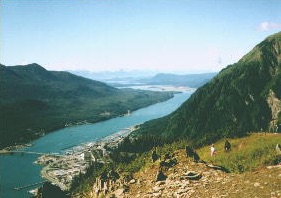
One of the most popular trips in Juneau. Take the tram from South Franklin Street (downtown). Food, gifts, theatre at top, and start of trail that gradually climbs to Gastineau Peak, Mt. Roberts and related ridges overlooking Silverbow Basin (home of the original major gold mines, and large Glory Hole). Wildlife and views abound. The first steeper climb area after leaving the tram building leads to a popular cross/picnic area. Be sure to glance at the valley as you continue to climb. Not unusual to see a bear! Bring binoculars, camera (and water). Can keep going and going!
BEACHES/PARKS
Auke Recreation Area
Turnoff at 15.7 mile Glacier Highway A local favorite for beach walks and barbeques. Trails through the spruce forest, islands just offshore, resident harbor porpoise, seabirds, and sea lions; it’s lovely in any weather or season.
Boy Scout Beach
Access 25 mile Glacier Highway, to the left just before Herbert River. Rich in history, 1 ½ mile easy trail follows Herbert River along remains of old corduroy road (poles laid next to each other perpendicular to trail to prevent miring in the mud), then runs through meadow and forested areas; further along you will find spectacular views of the Chilkat Range, Lynn Canal and Coastal Range.
Eagle Beach
Approx. 26 mile Glacier Highway. Scenic and sandy and home to many eagles. A great place for a picnic!
False Outer Point & Bluff Trail
At 11.4 mile North Douglas Highway, you’ll find a trail head at the end of a large parking space overlooking the water. This trail will lead you gently down to the beach where picnicking, beach combing, and more trails await. Sea lions, sea ducks, gulls and all manner of intertidal beach life such as sea stars, urchins, snails, limpets, chitons and more can be found. Follow the paths through the old forest or the beach at low tide to the beaches on the west side of False Outer Point.
Sandy Beach/Savikko Park
Cross the Douglas Bridge from downtown Juneau and turn left. Follow road to just beyond City of Douglas. Great area for ball games, beachcombing (former site of Treadwell: pottery shards, tiles abound!), hanging on the beach. Location of the new ice rink.
COVE BEACHES
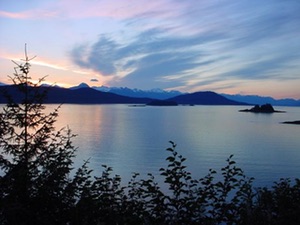
There are several small beach coves and viewpoints (Yankee Cove, Sunshine Cove, Bridget Cove, Echo Cove) stretched along miles 34.5 to the end of Glacier Highway. Beautiful secluded spots close to the road offer pretty picnic sites and often great whale watching. Nice camping sites.
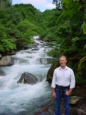
WATERFALLS
East Glacier Loop Trail/Nugget Creek Falls
East Glacier Loop Trail/Nugget Creek Falls are good places to visit for falls-watching. The base of Nugget Creek Falls can be accessed from the Mendenhall Visitor's Center. Or simply drive south of downtown along Thane Road for many cascading falls and views of Gastineau Channel.
Ebner Falls
Ebner Falls, shortly after the trailhead to Perserverence Trail, provides a great place to relax and enjoy the romance of the falls. This is one of my favorite short getaways for a short hike that will transcend you to another place in your mind.
Salmon Creek Falls
At 4 mile Egan Drive to Hospital Drive then left past Tlingit/Haida Community Building and Salmon Creek Mini Storage along the road that goes past the defunct fish hatchery. The beautiful lower falls on Salmon Creek is well worth the 15 minutes walk.
Suicide Falls
3 mile Thane road. This is a very pretty falls close to the road. Across the road is a steep short trail to the beach. Great place close to town for a beach stroll and picnic.
Sawmill Falls
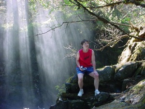
Absolutely gorgeous! Take kayak from Echo Cove (end of road). Be sure to check tides so that you are going through the narrow mouth of Cove either with the tide or at slack tide! Approximately 1.5 hours of paddling to Sawmill Cove. The falls are most easily accessed by a trail toward the mouth of the cove (look for a small group of trees on the landward side of cove). Beware: during salmon runs, many bear frequent the area.
DOCKS AND HARBORS
Enjoy watching the fishing, yachting and cruising activity and wonderful sunsets at the many docks in Juneau, Auke Bay and Douglas. Fisherman's Bend is a nice dock in the afternoon for eagle watching and pictures.